Linton Bay Survey and
Community Management Plan
Project Summary
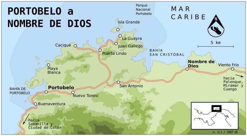
This project will train community stakeholders in fisheries management and employ those stakeholders in the production of a management plan for the ecological restoration and sustainable mixed use of the marine environment of Linton Bay, adjacent to the town of Puerto Lindo, in the heart of Portobelo National Park.
Internationally-standardized surveying activities will be conducted alongside simultaneous digital survey methods using computer vision and photogrammetry. Surveys will be performed quarterly and subsequent community meetings will present the results and make management recommendations.
The entire process, from initial community recruitment through final Community Management Plan presentation, will be video documented and produced into a 20-minute documentary to be posted on the project website alongside the final Community Management Plan and an interactive photogrammetric map.
Project Purpose and Procedures
Unsustainable practices over the past decade, combined with the increased pressures of climate change, have depleted the bay’s resources to the extent that even sustenance fishing is no longer possible.
A survey of Linton Bay’s present habitat conditions and species populations will provide the baseline data necessary for creation of a fishery management plan to restore Linton Bay. Quarterly surveys will identify trend-lines while enabling the community to directly, and objectively, gain awareness of those trends.
At the quarterly community meetings marine biologists will discuss survey results, propose options for ecological restoration, and relay results from efforts in similar coastal marine ecosystems. The goal of the meetings is to strive for consensus on the key aspects of a sustainable mixed-use management plan for Linton Bay.
The creation, and quarterly updating, of a photogrammetric map of the bay will visually illustrate the trending health of the seafloor in the most overt way possible. And species counts, manually observed and recorded by community members, will provide objective data on population increases and decreases.
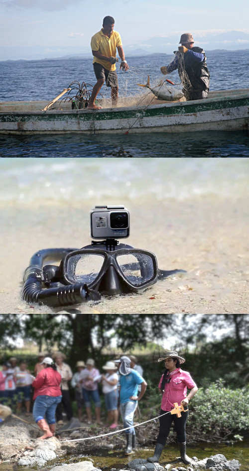
To enhance the value of the community members’ manual efforts, and to validate the accuracy of the data collected, each observer will video-document their survey efforts via a head-mounted GoPro camera. A computer-vision process applied to the collected GoPro footage will digitally identify and count species. Additionally, the same footage will be processed via photogrammetry into a 3-D map of Linton Bay, on which the varying habitats of the seafloor can be neatly marked and measured.
Use of this low-cost (relative to LiDAR scans and SCUBA dives) survey and mapping technology will enable the fishing community of Puerto Lindo to collect highly accurate marine habitat survey data while building the knowledge required for sustaining an ecologically and economically productive fishery. We anticipate building upon the successful completion of this project by replicating the process in fishing communities along the entire coastal region of Portobelo National Park.
Project Objectives
Initially:
- Cultivate community support for the creation of a Community Management Plan for Linton Bay.
- Design a marine ecosystem survey plan for Linton Bay.
- Train ~15 members of the Puerto Lindo Fishing Co-op (JPUL) how to collect the survey data.
- Outfit the survey crew with snorkeling gear, manual record-keeping tools, head-mounted GoPro cameras, head-mounted GPS trackers, and safety floats.
Quarterly: - Conduct the marine ecosystem survey of Linton Bay.
- Collect and compile manually-recorded survey data into results.
- Collect and scan GoPro footage via a purpose-built Amazon SageMaker image classification algorithm.
- Collect GoPro footage and process via photogrammetry software into 3-D map of the survey area.
- Finalize manually-collected data and digitally-collected data into survey results and recommendations and post an interactive final report on the project website for public viewing.
Close-out: - Produce a 20-minute documentary on the process of creating a Coastal Marine Management Plan via community recruitment and employment.
Expected Results
Initially:
- Establishment of community support for the project.
- Organized strategy for coordinated teams of snorkelers to survey existing populations of flora and fauna.
- Transfer of coastal fisheries management knowledge and supervised practice of survey techniques.
- Transfer of snorkeling, record-keeping, and GoPro camera techniques specific to the survey.
Quarterly: - Raw data recorded on individual reports by each surveyor.
- Assembly of a master spreadsheet which organizes all the data from the individual reports.
- A spreadsheet detailing organism counts/size as identified by the computer from the video footage.
- A detailed 3-d photogrammetric map of Linton Bay.
- A valuable resource for both community and scientific usage, providing an underwater “google map” of Linton Bay and identifying the accuracy of computer vision versus manual observation for the purposes of conducting marine ecosystem surveys in coastal environments.
Close-out: - An easily-digestible presentation of the strengths and challenges of fully integrating a coastal fishing community in the creation of their own Coastal Marine Management Plan.
Project Timeline
| Monthly Timeline | |||||||||||||||
|---|---|---|---|---|---|---|---|---|---|---|---|---|---|---|---|
| ACTIVITY | 1 | 2 |
3 |
4 | 5 | 6 | 7 | 8 | 9 | 10 | 11 | 12 | 13 | 14 | 15 |
| Design Survey Plan | |||||||||||||||
| Community Engagement and Recruitment | |||||||||||||||
| Video Recording of Community Participation | |||||||||||||||
| Design Training Program | |||||||||||||||
| Train and Outfit Survey Crew | |||||||||||||||
| Conduct Survey | |||||||||||||||
| Compile Manually-Collected Data | |||||||||||||||
| Collect Sample Data and Train Image Classifier | |||||||||||||||
| Extract Data from GoPro Footage | |||||||||||||||
| Build Photogrammatric 3-D Map | |||||||||||||||
| Compile Survey Results | |||||||||||||||
| Present Results and Recommendations to Community | |||||||||||||||
| Post Results on Project Website | |||||||||||||||
| Edit Documentary Footage | |||||||||||||||
| Project Close-out | |||||||||||||||